York County
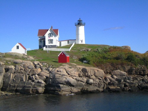
Cape Neddick 1879 – 41-foot white cast-iron conical tower, on summit of Cape Neddick Bubble, a small offshore rocky islet. Off Route 1A, York. Otherwise known as “Nubble Light”.
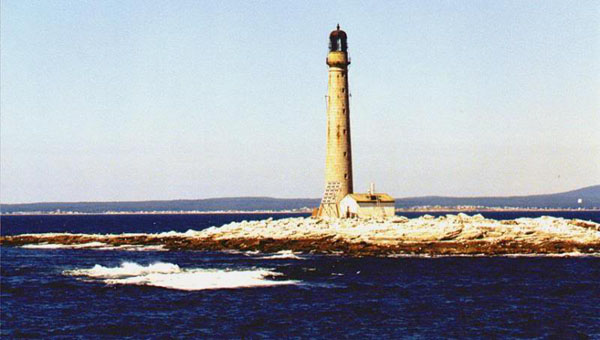
Boon Island 1811/1855 – 133-foot gray granite conical tower, 6 miles east of York Beach
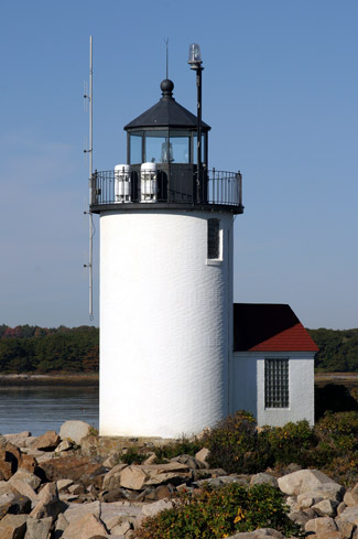
Goat Island 1833/1859 – 25-foot white cast-iron cylindrical tower. Cape Porpoise Harbor entrance, Kennebunkport
Wood Island 1808/1858 – 49-foot white granite conical tower. Saco River entrance, Biddeford Pool, Biddeford.
Greater Portland
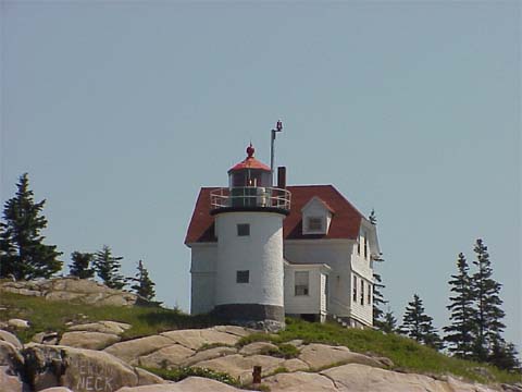
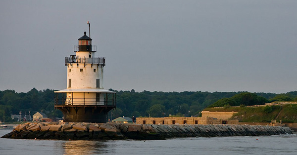
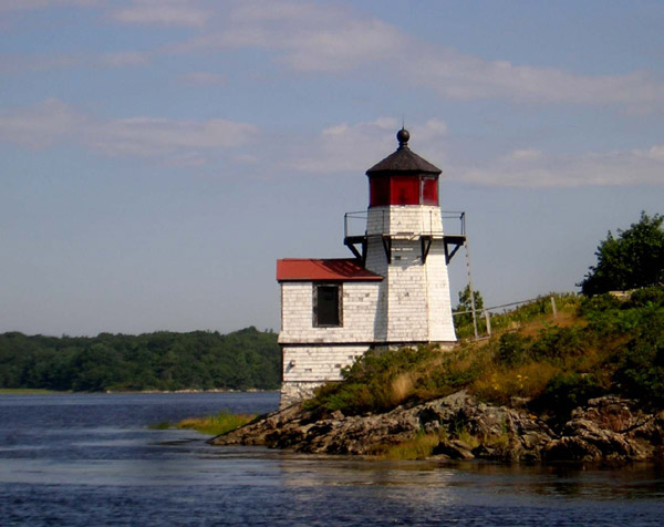
Spring Point Ledge 1897 – 54-foot white brick and cast-iron cylindrical tower on breakwater. West side main channel, Portland Harbor, South Portland.
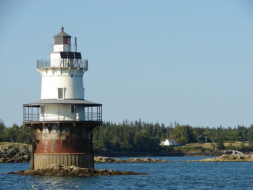
Portland Breakwater 1855/1875- 20-foot off-white cast-iron cylindrical tower atop octagonal pier. West side main channel, Portland Harbor, South Portland
Ram Island Ledge 1905 – 77-foot gray granite conical tower. North side Portland Harbor entrance, Portland, view from Portland Head
Portland Headlight 1791 – 80-foot white fieldstone and brick conical tower. South side Portland Harbor entrance, Cape Elizabeth.
Cape Elizabeth – East Light 1827/1874 – 67-foot white cast-iron conical tower, on Staples Point, southeast tip of Cape Elizabeth, view from Dyer Point, active; West Light, 300 yards north, privately owned and inactive
Halfway Rock – 77-foot white granite conical tower, 10 miles east of Cape Elizabeth off Harpswell Neck, can be seen from Portland Head or land’s end, Route 24, Bailey Island


Midcoast
Pond Island 1821 – 20-foot white cylindrical tower, summit of island. West side of Kennebec River entrance, view from Popham Beach, Phippsburg.
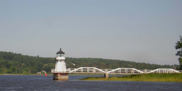
Doubling Point 1898 – 14-foot white wooden octagonal tower on granite pier with footbridge to shore. East bank Kennebec River, Arrowsic
Squirrel Point 1898 – White wooden octagonal tower. East bank Kennebec River, Georgetown, view from Parker Head Road, Phippsburg Center
Perkins Island 1898 – White wooden octagonal tower. West side of island, Kennebec River, view from Parker Head Road, Parker Head
Seguin Island 1795/1887 – 53-foot white cylidrical tower, 2 miles south of Kennebec River mouth, Georgetown, view from Popham Beach
Hendricks Head 1829/1875 – 39-foot white square tower, privately owned, Southport Island, Sheepscot River, Southport. (Tower and/or grounds privately owned; respect signs).
Burnt Island 1821- 26-foot white conical tower. West side, Boothbay Harbor entrance, Southport; view from Spruce Point, Boothbay Harbor
The Cuckolds 1892/1907 – 48-foot white wooden octagonal tower atop dwelling. Off Cape Newagen, west side entrance to Boothbay Harbor, view from town dock, Newagen.
Ram Island 1883/1977 – 30-foot white cylindrical tower, northwest side of island, east side of Boothbay Harbor entrance, view from Ocean Point, Route 96, Boothbay
Pemaquid Point – 32-foot white fieldstone conical tower, Pemaquid 1827/1857 Bristol, end of Route 130.
Monhegan 1824/1850 – 47-foot gray granite conical tower, 10 miles offshore, Monhegan Island, via car ferry from Boothbay Harbor, New Harbor, Port Clyde.
Franklin Island 1805/1857- 37-foot white cylindrical tower, northwest side of island, Muscongus Bay, Friendship
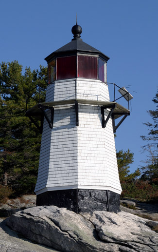
Marshall Point 1832/1858- 25-foot white granite tower with footbridge. Southern tip of Marshall Point, east side southern entrance to Port Clyde Harbor entrance, view Lighthouse Road off Route 131. St. George.
Tenants Harbor 1857 – 26-foot white cylindrical tower, privately owned. East side of Southern Island, view from the village
Two Bush Island 1897 – 42-foot white square tower. Off Tenant’s Harbor, north side Two Bush Channel
Whitehead Island 1807/1852- 34-foot gray granite tower, west side, southern entrance to Muscle Ridge Channel. Off Tenant’s Harbor, St. George
Rockland Breakwater 1888/1902 – 18-foot white square tower atop fog signal house. North side, Rockland Harbor entrance, Rockland.
Owl’s Head 1825 – 20-foot white brick conical tower, south side entrance to Rockland Harbor, view from Lighthouse Road off Route 73.
Indian Island 1850/1874 – 31-foot white square tower, privately owned, no longer active. East side off Rockport Harbor entrance, view from Rockport Marine Park.
Curtis Island 1836/1896 – 26-foot white cylindrical tower. Camden Harbor entrance, view from Bay View Street, Camden
Grindel Point 1851/1874 – 32-foot white pyramidal tower, privately owned. Islesboro, auto ferry from Lincolnville Beach; north side entrance to Gilkey Harbor.

Downeast
Heron Neck 1854 – 22-foot white cylindrical tower. Green Island, Vinalhaven, ferry from Rockland
Brown’s Head 1832/1857 – 24-foot white brick cylindrical tower. Fox Islands Thorofare, Vinalhaven, ferry from Rockland.
Goose Rocks 1890 – 51-foot white cast-iron conical tower. Fox Island Thorofare, between North Haven and Vinalhaven, via ferry
Saddleback Ledge 1839 – 42-foot gray granite conical tower. Between Isle au Haut and Vinalhaven, via ferry
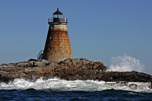
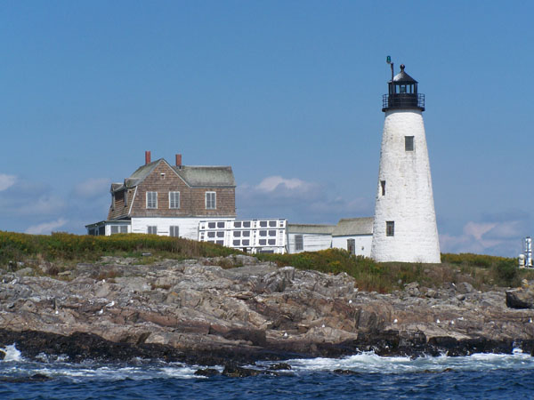
Matinicus Rock 1827/1857- Two 48-foot gray granite cylindrical towers, 5 miles southeast of Matinicus Island
Fort Point 1836/1857 – 26-foot white square tower. Penobscot River mouth, east end of Cape Jellison, view end of Fort Point Road, off Route 1, Stockton Springs.
Dice Head 1829 – 45-foot white conical granite and fieldstone tower, privately owned, Castine Harbor entrance, view end of Lighthouse Road, Castine.
Isle au Haut 1907 – 48-foot white cylindrical brick tower with footbridge to shore. Robinson Point, Isle au Haut via ferry.
Mark Island 1857 – 26-foot white square tower, west entrannce to Deer Island Thorofare, Stonington
Eagle Island 1839/1858 – 28-foot conical tower, East Penobscot Bay, Deer Isle
Pumpkin Island 1854 25-foot white conical stone tower, privately owned.West end of Eggemoggin Reach, view end of Eggemoggin Road, off Route 15, Little Deer Isle
Blue Hill Bay 1856 – 22-foot white cylindrical tower, Green Island, Brooklin, inactive; west side of Blue Hill Bay.
Burnt Coat Harbor 1872 – 33-foot white square tower. Hockamock Head, Swan’s Island, view from ferry from Bass Harbor.
Bass Harbor Head 1858 – 26-foot white cylindrical tower. Southern end of Mount Desert Island, view end of Lighthouse Road off Route 102A, Bass Harbor.
Bear Island 1839/1889- 25-foot white cylindrical tower. Northeast Harbor entrance, Cranberry Isles
Baker Island 1828/1855 – 43-foot white stone cylindrical tower, center of island. Cranberry Isles, outer entrance to Frenchman Bay
Great Duck Island 1890 – 42-foot white cylindrical tower. Off Cranberry Isles, east side of entrance to Blue Hill Bay, Frenchboro
Egg Rock 1875 – 40-foot white square tower atop dwelling. Frenchman’s Bay entrance, Winter Harbor, view from Park Loop Road, Bar Harbor
Mount Desert Rock 1830- 58-foot gray granite conical tower. 18 miles southeast of Mount Desert Island
Winter Harbor 1856- 19-foot white cylindrical tower, privately owned. Mark Island, west side of entrance to Winter Harbor, view from Loop Road.
Prospect Harbor Point 1850/1891 – Prospect Harbor entrance, view Route 186, Gouldsboro.
Narraguagus (Pond Island) 1853- 55-foot white stone cylindrical tower, privately owned. Pond Island, Millbridge, west side entrance to Narraguagus Bay.
West Quoddy Head Light 1808/1858 – authorized for construction by Thomas Jefferson. 49′ red-and-white horizontally banded brick conical tower. Westside entrance, St. Croix River and Cobscook Bay, view end of South Lubec Road, off Route 189, Lubec. Located in Quoddy Head State Park.